Comprehensive online reports and street mapping


liveTracking data is displayed in real-time with Microsoft® Virtual Earth™

liveTracking online mapping
Our highly advanced in-house software designers have developed an incredible online application that enables you to follow any land/sea vehicle in the UK every few minutes.

This application can be used to accurately track the precise location of freight to stolen vehicles, which is then compiled into a comprehensive report

What's more, all of the locations of the fleet of vehicles is updated in real time - each vehicle is pinpointed precisely on the map, so our customers know exactly where each vehicle they have registered is, and how far from its destination there is left to go.


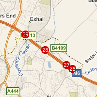
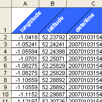
Effective data output
Huge amounts of data can be derived from the activities of the fleets. The limits are endless, with data that includes longtitude, latitude, speed, date, time and more.

With the vast amounts of data compiled, liveTracking can then export this data into CSV format, which can be imported into spreadsheet packages and other management software to highlight trends.


liveTracking data is displayed in real-time with Microsoft® Virtual Earth™

Time-trigger and distance-trigger
liveTracking supports two different triggers to update the reports. The updates can be set to update either by time or by distance, so for example, the report can be configured to update every 10 minutes, or to update every 3 miles a vehicle has travelled.

The basic package allows updates every 5 minutes or 1 mile travelled, whereas the advanced package allows updates every 1 minute or 1 mile.